


On the Hunt for Uranium in Bears Ears
After President Trump reduced Bears Ears National Monument by 85 percent, environmentalists predicted mining companies would soon overrun the landscape. But is there really any uranium to dig up? We decided to have a look for ourselves.
Heading out the door? Read this article on the Outside app available now on iOS devices for members! Download the app.
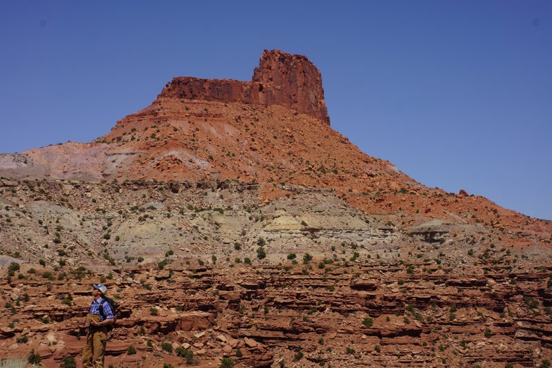
At the west end of the canyon country formerly designated as Bears Ears National Monument, a 1,000-foot sandstone spire known as Jacob’s Chair stands over the desert floor like a pistol pointed at the sky. The Chair, red as a raw steak and buttressed on one side by a mesa that is the formation’s namesake, sits in what geologists call the White Canyon uranium district. It’s big slickrock land dominated by sun and wind, where miles of scrubby desert separate flat-topped mesas.
A few miles south of Jacob’s Chair, a primitive two-track dirt road cuts an arrow-straight line from the graded Bureau of Land Management road to the base of a mesa overlooking Cheesebox Canyon. At the top of the mesa, where a portion of the ragged cliff was missing, my map showed an old adit, or mineshaft. At one end of the scar, an apron of purple and gray talus spilled down the slope.
“Every mine has a dump, because the rock you want is almost always covered by rock you don’t want,” said Jason Price, a geologist friend who’d come to southern Utah to help me find uranium. “You bulldoze the rock you don’t want, and you can often see those dumps.”
From the base of the mesa, the access road to the mine angled up through the layer-cake stratigraphy that characterizes much of the Colorado Plateau, the roughly 240,000 square miles of high desert surrounding the Four Corners region of Utah, Colorado, Arizona, and New Mexico. The sedimentary rocks found there hold some of the richest uranium deposits in the United States—about 90 percent of the uranium mined for the federal government during the country’s Cold War weapons buildup came from the same formation of yellow sandstone that sat at the top of the old mining road in front of us.
We’d come to the area to see if the rock therein contained enough uranium to warrant the national dialogue that had ensued after President Trump reduced the monument size by 85 percent in 2017. Media headlines rang out news that the area was open for business to uranium companies. Most of the reporting pointed to Trump finally granting those companies their wishes. I wanted to see if bulldozers were crawling through the desert, if claim stakes with orange flagging tape topped every hill, and if what had been a quiet corner of desert roughly the size of Rhode Island had come under the industrial knife. And since any U.S. citizen can stake a claim on public land, a right granted by the Mining Law of 1872, I decided to stake my own claim, if only to protect a slice of land that I considered worth preserving.
So I rang up my geologist pal, Jason Price, who had just earned his doctorate in hard-rock geology from California Technical Institute, and told him the plan: We would stake a claim in an area that had value as a recreational destination, provided some kind of significant habitat for wildlife, and held the potential—if not outright evidence—of archeological value. Ideally, it would also be open to grazing, fuel-wood cutting, mining, and whatever else people used land for in southern Utah. We’ll climb a mesa, I told him, and find a 20-acre slice of land that incorporates as many uses and interests as possible. The preeminent requirement, though, was that between the surface of that 20 acres and the molten center of the earth, there had to be some uranium.
As Jason and I leaned on the hood of the truck and looked at the mine dump above Cheesebox Canyon, we reckoned no one would blast a road up the side of a mesa and bulldoze a quarter-mile of cliffline without believing the rock had enough uranium to make the cost and effort worthwhile. There’s a mantra in field geology: The best way to know about a rock is from a boots-on-the-ground perspective. So we climbed the old road, past radiant fractures in the rock left by crude dynamite, past a striped whipsnake that was more curious about us than afraid, and past a veritable tree trunk of petrified wood that looked like it had been spray-painted orange.
“The woody debris is commonly radioactive,” Jason said. He’d been saying that for the past two days, but the scintillometer, a device that detects radiation, hadn’t obliged him. As we climbed toward the mine, we began to get chirps from the dense, phone book–sized gamma ray scintillometer that had quickly become my least favorite piece of gear to carry. (Geiger counters, though more widely known, are “way old-school,” according to one geologist, so Jason borrowed a “scinto” instead.) It crossed my mind that radioactive rocks were a hell of a thing to go looking for, but Jason, fully decked out in his geological kit—the pockets of his field vest bulging with who knows what, his spiked hammer swinging at his side, and his pants tucked into gaiters covering his heavy leather boots—led the way toward “better readings.”
Like every other heavy metal on earth—including gold, silver, and platinum—all uranium on the planet was created billions of years ago when distant stars collided. Uranium, the heaviest of all metals, is radioactive. It emits gamma radiation as its molecular composition changes. That change is called decay, and it happens continually in all naturally occurring uranium.
“A gamma ray is a punch of energy,” Jason said. “It’ll go right through this scintillometer, right through you, right through your truck.”
Harnessing that energy into a weapon became a priority during World War II. In 1942, a team of scientists at the University of Chicago initiated the first controlled nuclear chain reaction as part of the Manhattan Project. J. Robert Oppenheimer and his team developed the bomb’s trigger, which would initiate the reaction inside the bomb, at Los Alamos National Laboratory in New Mexico, and the first atomic weapon was detonated at the Trinity Site, also in New Mexico. Three weeks after that, on August 6, 1945, the United States dropped “Little Boy,” a uranium-based bomb on Hiroshima, Japan. Three days later, it dropped “Fat Man,” a plutonium-based bomb on Nagasaki, ending the war and killing more than 100,000 people.
From then until the late 1970s, the Cold War drove the demand for uranium. At the same time, nuclear power plants began to come online. The Soviet Union built the world’s first commercial nuclear power plant in 1954; the United States built its first in 1957. As the the modern environmental movement took off in the 1960s, nuclear power gained favor as an environmentally friendly alternative to fossil-fuel energy. That momentum stalled out in 1979, when the Three Mile Island Nuclear Generating Station in Pennsylvania had a malfunction with its cooling system and a partial nuclear meltdown ensued. The uranium market crashed. The price of the commodity U3O8—or yellowcake, a form of concentrated uranium that’s undergone initial processing at a mill—fell from about $100 per pound to $27.50.
“Three Mile Island was like a guillotine to the industry,” Jason said. We were sitting around a fire at camp, trying to connect the dots between the small mine sites that we’d been seeing in the Bears Ears area and the market that drove the mining. “And then came Chernobyl in 1986 and Fukushima in 2011. Those have been major setbacks to the industry.”
Jason nearly took a job with a uranium company in 2005, during uranium’s latest price increase, but decided the industry was too fickle. ln 2007, the price of U3O8 reached a high of nearly $140 per pound; in 2008, it fell to almost $40. The BLM database for mining claims in the Jacob’s Chair area reflects the peaks and valleys of the market.
“It’s a boom-and-bust industry. It’s the same with all mining,” he said.
The current spot price of uranium is roughly $26 per pound of U3O8. As it happens, the U.S.’s only operating conventional uranium mill, where uranium is extracted from the ore once above ground, sits just east of the current boundary of Bears Ears National Monument: the White Mesa Mill, owned and operated by Energy Fuels Resources.
Like 60 percent of all mining companies in the world, Energy Fuels is based in Canada—which is considered to be a friendly regulatory environment for mining companies—but its offices are outside Denver, and most of its operations are in the Southwest. On the other side of Bears Ears from the White Mesa Mill, the company owns the Daneros uranium mine, which has sat dormant since 2010 due to the low price of the ore. When President Obama created Bears Ears National Monument, in 2016, he drew the monument boundaries around both the mine and the mill.
“We woke up one morning, and the road to our mine, Radium King Road, was suddenly going to be inside a national monument. We didn’t want that,” said Curtis Moore, vice president of marketing for Energy Fuels. The company also asked for a buffer of land between its mill and the monument’s east boundary. “We have environmental sensors around the mill that we wanted a mile or two from the boundary.” So Energy Fuels paid a firm of lobbyists $30,000 and got what it wanted. (The outdoor industry spent millions on ads but still lost.)
The current low price of uranium is a result of a global oversupply of the commodity. But there are signs that the price could rebound in the foreseeable future. In May, the White House released a U.S. Geological Survey report identifying 35 minerals critical to national security, and uranium made the list. China currently has 15 nuclear power plants under construction. An increase in the price of U3O8 could potentially restart operations at the Daneros mine, but the old mines inside the area formerly designated as Bears Ears would almost certainly remain quiet.
“The thing about the Bears Ears area, there are a few uranium deposits there, but they’re not that good,” Moore said. “All those little mines you see out there are from the days of the mom-and-pop miner, and those days are over. Bigger companies are the only ones today who can comply with all the health and environmental rules and regulations and do it at a large enough scale for it to make economic sense.”
Calling the mine we hiked to above Cheesebox Canyon a mom-and-pop operation implies that Mom and Pop were pretty handy with a bulldozer. A quarter-mile of cliffline was missing. Berms of rock had been pushed into lines. Pads big enough to land a helicopter on had been graded flat. The apron of gray and purple talus that we’d seen from the road ran for 100 yards down the side of the mesa like a rock glacier.
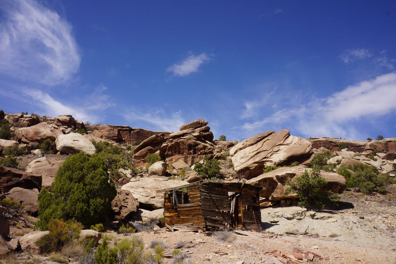
The site was typical of most mid-20th-century mines: dangerous to investigate, littered with colorfully mineralized rock, and made partially safer for the public by federal dynamite. An old cabin with a caved-in roof leaned downwind. A spilled bucket of tar, which had hardened soon after being knocked over 50 years or so ago, was eroding out of the sand beneath it, not dissimilarly from the balanced boulders and columnar hoodoos found all over the Colorado Plateau. A five-foot hole in the slope behind the old cabin was the only access to the mine that hadn’t been blasted closed.
Investigating abandoned mines is best left to bats and insects, but the climb down into the shaft looked doable. I was at the mouth of a vent, a vertical shaft blasted for air circulation. The air inside was cool and still. I asked Jason if we ought to check it out.
“Nah, that dust is bad news,” he said. It was his umpteenth comment about the potential health risks of what we were doing. I asked him if the public should be more concerned about mining within the perimeters of the former national monument or the health of past and current uranium miners. He was looking at a map, only half paying attention.
“Well, either way, that’s Cheesebox Canyon Wilderness Study Area right in front of us, and it’d be a nightmare to put in a project here,” he said. “Mining companies don’t want to work in the U.S. because of things like this.”
A National Geographic Trails Illustrated map of the area around the former Bears Ears monument shows at least 13 different land designations. Wilderness areas, wilderness study areas, instant study areas, BLM-managed land, Forest Service–managed land, a national park, a national recreation area, a national monument, a state park, two Indian reservations, urban land, private land, and square-mile parcels of state trust land, called school sections, owned by the state of Utah and almost always shaded blue on maps. To a mining company, this is a difficult landscape to work in.
One reason the Bears Ears area is unlikely to see future development is the low quality of the deposits. “The rock’s just not that rich,” Jason said one afternoon, after days of testing thousands of rocks with the scinto. The other reason is that mining in the vicinity of Natural Bridges National Monument, Dark Canyon Wilderness Area, and other parcels of protected land comes with a lot of what a geologist would call red tape.
Individuals and corporations have come into the area in waves over the years, but since President Trump reduced the monument, the majority of people in the area claiming mineral rights have been a handful of journalists who wanted to get some dirt under their fingernails and a pair of activist bloggers who wanted to stage an act of protest.
It’s been done before. In 2008, climate activist Tim DeChristopher bid $1.8 million on oil and gas leases at a BLM auction and spent two years in federal prison because he couldn’t pay the bill. Then, in 2016, Terry Tempest Williams bought the rights to 1,120 acres of BLM land in Utah, though the BLM stripped it from her after she wrote an op-ed about planning to leave the resources in the ground.
Before our trip, I talked about our plan with Salt Lake City–based attorney Pat Shea, who represented DeChristopher and briefly advised Williams. I wasn’t interested in performing an act of civil disobedience—even if my editor, who was probably enjoying kale milkshakes while I was out prospecting, wanted me to be. But I did want to stake a claim without being crosswise of the feds. I told Shea that we’d be carrying a gamma ray scintillometer to ensure that we had what the Mining Law of 1872 calls “proof of discovery,” or evidence of a valuable resource.
“I don’t think that’s necessary, but I think it’s prudent,” Shea said. “It’s sort of a belt-and-suspenders approach.”
I worried about our legitimacy because I had no intention of getting into the mining business. Jason is a geologist, I told him, but I am not a legitimate miner.
“No, no,” Shea said. “Under the 1872 law, you’re a legitimate miner. The law doesn’t say what’s legitimate and what’s not legitimate.”
Shea left me assured that I was totally legal in staking a claim, even if the act had been used as a flat-footed act of defiance by environmentalists. If you can satisfy the requirements of the Mining Law of 1872 and precisely lay out your claim, Shea told me, your biggest worries will probably be sunbathing rattlesnakes and ornery locals.
A necessary part of staking a claim is knowing exactly where it’s located. The first place we stopped to get maps of the Jacob’s Chair area was a custom map shop run out of a modest one-story house in Monticello, Utah. After knocking on the front door, I noticed a camera above the entryway. The welcome mat at my feet read, “Trespassers will be shot. Survivors will be shot again.” A nice woman answered the door and told us that the mapmaker, her husband, was currently in Idaho visiting friends. But she called him on the phone and soon enough fired up the four-foot-wide printer to sell us a large-scale map for $10 cash.
To get the most recent map of the monument boundaries, we stopped at the BLM Kane Gulch field office. On a Sunday at 8:30 a.m., the place swarmed with people. Some were getting backcountry permits; some were buying maps and guidebooks; some were reading the archeological interpretive displays. Most were dressed in quick-dry clothing. The BLM volunteers manning the post looked stressed. I’d heard that they were understaffed and overwhelmed, and I asked the gray-haired man behind the desk if the office was always so crowded.
“Coupla hundred people a day through here,” he said, shaking his head. I told him I was writing a story about uranium in Bears Ears.
“Don’t,” he said. “Don’t write any more about this place.”
We left without telling him that we were claiming the mineral rights to 20 acres north of his field office. But after nearly a week in camp, we still didn’t know which 20 acres. I had originally wanted to find a uranium deposit in a place that was undoubtedly used in multiple ways or had values to multiple parties, and Jacob’s Chair seemed to fit the bill. Rock climbers have been to the top of the red spire. Native Americans consider the area sacred, and an archeological survey of the area had found and documented 13 prehistoric sites on the mesa below the chair. Along the valley floor, a few skinny cattle grazed on what little scrub they could find.
On our first night in camp, we passed a group of 30 or so sunburned women who had clearly been living out of their backpacks in the desert. Later that night, a dozen ATVs passed us, headlights casting cones of light in the dust. For three days, a pair of vans from Colorado Mountain College was parked at a nearby trailhead. What we hadn’t found was a uranium deposit worth claiming.
“My impression is that the issue of uranium mining in this area is overblown,” Jason said. “Even if you were to bulldoze this whole mesa, it wouldn’t be worth it.”
That was part of what troubled me: Where was the pay dirt that would satisfy the Mining Law’s “prudent man rule?” The rule is the BLM’s way to define a valuable resource, and it says that a reasonable man would invest time and money into the site. I could only guess at what the feds considered a reasonable person, but I understood the rule to be a requirement for any claim. When Jason proposed that we stake our claim over camp, I countered that, for better or worse, we had no evidence of radioactive material here at camp. We need proof, I told him.
“No you don’t,” he yelled. “All you need is an idea.”
For all anyone knew, Jason argued, there could be a massive breccia pipe under the sand that could potentially hold way more uranium than any mom-and-pop mine we’d so far looked at—even if it was too deep for our scinto to pick up. The pipes are collapsed vertical caves that fill with a matrix of boulders and sediment. They’re shaped like carrots, can be more than 3,000 feet from top to bottom, and hold the richest uranium deposits in the United States.
Our camp at the base of Jacob’s Chair straddled a shallow arroyo, with a large sand dune partially anchored by juniper and sagebrush on one side and a natural amphitheater of red cliffs on the other. Ravens wheeled in the clear skies above us every day, and every night a small bat flicked over camp in the evening light. I asked Jason if other geologists would call us nuts for thinking a breccia pipe might be under it all.
“Nope. No one can say anything until you test the rock.”
So, the next morning, we staked our a 20-acre rectangle laid out on an east–west axis and marked at the four corners by hip-high monuments of stacked rock. At the center of the claim, near the sandstone shelving that served as our kitchen, I sank an old juniper fence post to mark the spot. It hardly looked different from the snags and withered trunks surrounding it.